Community
Getting Around Wollongong: Roads, Public Transport and Connections
A plain-English guide to how Wollongong and the wider Illawarra move, from the coastal highways and the South Coast rail line to local buses and the Sydney commuter run.
Community
A plain-English guide to how Wollongong and the wider Illawarra move, from the coastal highways and the South Coast rail line to local buses and the Sydney commuter run.
This is a general explainer about how people travel in and around Wollongong, not financial, investment or business advice, and the specifics can shift over time. Routes, timetables, fares and project timelines are reviewed regularly by the agencies responsible, so anyone planning a move, a commute or a property decision should confirm current details directly with Transport for NSW, Wollongong City Council and the relevant operators before relying on them. What follows focuses on the durable shape of the network rather than precise numbers that date quickly.
What makes getting around Wollongong distinctive is geography. The city is pinned in a narrow coastal strip between the Tasman Sea and the steep wall of the Illawarra Escarpment, so most movement runs north to south along the coast rather than sprawling in every direction. That escarpment is the single biggest fact of local travel: the climbs and descents through Mount Ousley, Mount Keira and Mount Pleasant shape where roads can go, and the dramatic Sea Cliff Bridge, which carries Lawrence Hargrave Drive out over the water at Coalcliff, exists precisely because there was no stable ground to build on against the cliffs. Transport for NSW manages the major state roads through this corridor, while Wollongong City Council looks after the dense network of local streets that thread between the beaches, the university and the suburbs.
The road spine of the region is the Princes Motorway and the Princes Highway, which together run the length of the Illawarra and connect Wollongong south towards Shellharbour, Kiama and the wider South Coast. The key link to Sydney is Mount Ousley Road, the main freight and commuter descent off the escarpment that feeds traffic to and from the M1 Princes Motorway and the Sydney basin. Because so much movement is funnelled through a handful of escarpment crossings, Transport for NSW treats these routes, and Mount Ousley in particular, as critical infrastructure, with ongoing work over the years to improve safety and traffic flow at the bottom of the descent. Within the city, Northcliffe Drive, Springhill Road and the Memorial Drive coastal route carry much of the cross-town load.
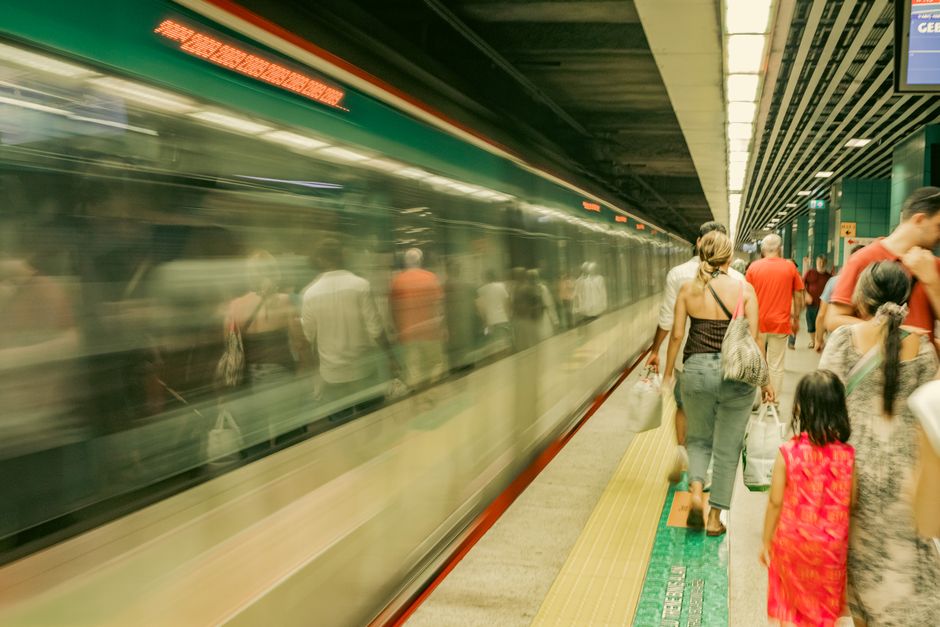
Public transport in Wollongong is anchored by the South Coast Line, the Sydney Trains and NSW TrainLink rail service that links Wollongong, Dapto, Thirroul and the northern coastal villages to Sydney via the spectacular climb through the Illawarra escarpment and the Royal National Park. For many residents the train is the practical way to commute to Sydney for work, and stations such as Wollongong, North Wollongong, Thirroul and Dapto are central to how the region connects to the metropolitan area. Local journeys are served largely by buses, and a standout feature is the free Wollongong city shuttle, a council-supported, Transport for NSW connected loop service that runs around the city centre, the hospital precinct, the university and the railway stations, which is unusual for a city of Wollongong's size.
Wollongong does not have light rail, trams or commuter ferries; its public transport is built on the rail line and an extensive bus network rather than on the tram or ferry systems some larger cities run. Buses across the Illawarra are coordinated under the Transport for NSW network, with services reaching the University of Wollongong, the major shopping centres, the beaches and the suburbs spreading south and inland. Fares and trips across train and bus services use the same Opal ticketing system that operates throughout the Greater Sydney and surrounding regions, which means a single card or contactless payment covers the train to Sydney and the local bus home.
For air travel, the region is served by Shellharbour Airport at Albion Park, a short drive south of the city, which the operating authority promotes as the Illawarra's gateway for regional and leisure flights and which is also home to the Historical Aircraft Restoration Society aviation museum. The airport has historically offered a modest schedule of regional services rather than a large commercial program, so many residents travelling interstate or overseas still drive or take the train north to Sydney's Kingsford Smith Airport. That long-running reliance on Sydney for major air links is part of why intercity rail and the road connection over the escarpment matter so much to the Illawarra's economy.
Typical commuting patterns reflect all of this. A large share of local trips stay within the Illawarra, by car along the coastal highways or by bus to work, study and the shops, while a significant and well-established flow of commuters travels to Sydney each working day, mostly by the South Coast Line or by car up Mount Ousley. The University of Wollongong, the hospital and the city centre are major destinations that the free shuttle and bus routes are designed to feed, and active travel is part of the picture too, with Wollongong City Council maintaining a popular shared coastal cycleway and foothpath network that runs along the beachfront and is used for both recreation and commuting.
On major projects, the durable theme is improving the escarpment connections and the road corridor rather than building entirely new transport modes. Transport for NSW has pursued upgrades to the Mount Ousley interchange and ongoing safety and capacity work along the Princes Motorway and Highway, while Wollongong City Council continues to invest in local roads, parking and the active transport network as part of its long term planning. Anyone weighing up where to live or work in the region should treat the train line to Sydney, proximity to a reliable highway on-ramp and access to the free city shuttle as the practical levers of getting around, and should check current timetables, fares and project status with the responsible agencies, as these are updated over time.
Sources: Transport for NSW, Wollongong City Council, Shellharbour Airport (Shellharbour City Council), Opal ticketing (Transport for NSW), NSW TrainLink.
This article was compiled by AI from the sources linked above and screened before publishing. See our editorial standards.
About this article
Published by The Daily Wollongong
More in Community